Google Maps on Monday provided online street views of remote locations around the world where wildlife is threatened by pollution and climate change, in time with the United Nations Climate Change Conference in Paris.
Originally providing panoramic photographs of cities and residential areas to users of Google Maps, Google Street View now allows users to virtually explore wilder settings, such as mountains, rainforests and ocean depths.
Some street views are constructed to give users a picture of the threats felt by people and animals in these areas.
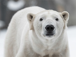
"From polar bears in the Canadian Arctic, to communities in the Brazilian Amazon, to blue oak trees in Central California, the impacts of climate change are being felt by plants, animals, and people across the planet," said Karin Tuxen-Bettman, outreach programme manager for Google Earth.
The new street views were constructed in collaboration with a number of organisations working to address environmental damage, and aim to showcase the work these organisations are doing.
Street views displaying polar bears and their vanishing sea ice in Manitoba, Canada were captured by Polar Bears International, while Amazonas Sustainable Foundation of Brazil offered scenes from the Amazon Rainforest.
Both organisations are using the street views they captured for their own educational purposes as well.
Bringing it home
Google's new street views aim to inspire people to act against climate change by making the effects of climate change more visible and accessible to users who may not otherwise notice them.
The imagery also allows for making comparisons over time, proving how environments are visually changing.
"Street View is great for visualising the impacts of climate change, but we're also using our Street View platform to measure climate data, which can be used by scientists, policymakers, businesses and citizens to drive better decisions," said Tuxen-Bettman.
For several years, Google Earth has worked with the Environmental Defense Fund to map methane leaks from natural gas lines under US cities, by adding special equipment to the cars that capture Street View images, Tuxen-Bettman added.
The cars will soon begin measuring other pollutants, including carbon dioxide, in partnership with environmental sensor network firm Aclima.
"Essentially, we're turning Street View cars into environmental sensing platforms," said Tuxen-Bettman.
Share