Johannesburg, Ekurhuleni and Tshwane town planners and officials will now have access to anonymous GPS data collected from Uber drivers.
The data can be used to help inform decisions on how to adapt existing infrastructure and invest in future solutions to make cities more efficient.
The e-hailing taxi service has created a Web site called Movement, which gives government free access to this traffic data.
The company hopes the traffic data insights will make it possible to measure the impact of road improvements and major events.
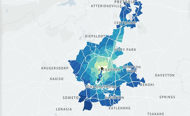
In Gauteng, Uber Movement measures zone-to-zone travel times; data that has historically been expensive and time-consuming to collect, and in the end is usually out of date.
Officials will be able to see how long the average travel distance time between places is and be able to set specific conditions, such as between weekdays and during peak traffic hours.
Over time, Uber will add more information - for example, automatically detecting potholes and utilising telematics data - and other cities.
The information is also available to third-party apps and the general public who want to explore insights such as travel times, patterns and the impact of rush hours, events and road closures.
Using the tool, for example, users can see the average time to drive between Sandton City and the Four Seasons Westcliff Hotel is 20 minutes 20 seconds. However, during peak morning traffic, it will take 22 minutes 15 seconds, and only 17 minutes 27 seconds in the evenings.
It also shows how the M1 double-decker bridge rehabilitation project which began in January last year increased drivers' commute by nearly 40% from 11 minutes 52 seconds to 16 minutes 34 seconds.
Head of public policy at Uber SA Yolisa Kani says: "Uber Movement is the next step to connecting further with our cities and having the opportunity to recognise its great transportation needs. With Uber Movement, we are able to further our mission in creating reliable transportation everywhere, for everyone."
Uber SA has signed an agreement with the Council for Scientific and Industrial Research (CSIR), which has agreed to share information and experience with Uber Movement.
"Transport planning is a data-intensive undertaking, and the required datasets tend to be expensive to collect and process. Having a platform that serves as a full-day transport network sensor would certainly help with the monitoring of some of the pertinent network indicators," says the CSIR's Dr Mathetha Mokonyama.
Uber Movement uses only aggregate, anonymous data and cannot be used to access any personally identifiable information.
This service is already available to other cities around the world.
In the US, Washington DC mayor Muriel Bowser says: "Smart technology and intelligent use of data are critical to the success of the nation's cities, and the District of Columbia is committed to using these tools to keep pace with the rapid growth of our neighbourhoods.
"We want to employ as many data sources as possible to mitigate traffic congestion, improve infrastructure, and make our streets safer for every visitor and resident in the US capital."
Share