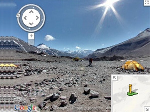
Google has added images of some of the most famous and highest mountain peaks in the world to its Street View service in Google Maps, allowing anyone in the world to experience the view from the top without having to actually climb them.
A Google team was sent to Everest (Asia), Kilimanjaro (Africa), Aconcagua (South America) and Mount Elbrus (Europe). Member of the expedition team and Google adventurer, Dan Fredinburg, says these mountains have been on Google Maps' bucket list.
"These mountains belong to the group of peaks known as the Seven Summits - the highest mountain on each of the seven continents. While there's nothing quite like standing on the mountain, with Google Maps you can instantly transport yourself to the top of these peaks and enjoy the sights without all of the avalanches, rock slides, crevasses, and dangers from altitude and weather that mountaineers face," says Fredinburg.
The imagery of the mountains and views were captured with a lightweight tripod and digital camera with a fisheye lens (equipment which Google says is usually used for its Business Photos program).
The street view images are now available within Google Maps on desktop and mobile. The Googlers who climbed the mountains to capture the footage have also posted a behind-the-scenes look at what went into the expedition on the Lat Long Blog. The team's favourite photos have also been added to the Street View Gallery.
Share